
Rio House Guidebook
Things in the area
The drive to the fall is very much a roller coster with hills and turns. Take lunch and be willing to go in the water when you get there it will be cold :).
10 locals recommend
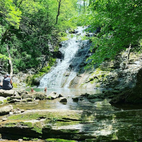
Elrod Falls
Elrod Falls RoadThe drive to the fall is very much a roller coster with hills and turns. Take lunch and be willing to go in the water when you get there it will be cold :).
call in advacne to make sure thy have room for you.
10 locals recommend

Shelly Belles Kayak and Tube Rentals
253 Carmony Lncall in advacne to make sure thy have room for you.

Tazewell Speedway
1400 Bacchus Rd
Woodlake Golf Club
330 Woodlake Blvd
Norris Lake

Straight Creek Boat Dock
775 Straight Creek Dock Rd
Clinch River

Morristown National Historical Park
30 Washington Place
Mountain Hollow Farm
553 Vancel RdMake sure you check the days it’s open beforehand.
Food scene
If you love a biscuit type breakfast sandwich this is the place strangely enough. 🤩 located on 25E heading toward town

bp
1959 Highway 25E SouthIf you love a biscuit type breakfast sandwich this is the place strangely enough. 🤩 located on 25E heading toward town

Zaxby's Chicken Fingers & Buffalo Wings
698 Winfield Dunn PkwyIs in morristown they give good protions and large salads.

Food City
1410 N Broad St
Holston's Kitchen
639 Dolly Parton Pkwy
Shelly Belle's Restaurant
325 Carmony LnThe Juice Spot
905 N Cumberland Dr
Cumberland Gap, Tennessee
Monday Closed
Tuesday 8:00 am - 5:00 pm
Wednesday 8:00 am - 5:00 pm
Thursday 8:00 am - 5:00 pm
Friday 8:00 am - 5:00 pm
Saturday 8:00 am - 5:00 pm
Sunday Closed

The Juice Spot
The Juice Spot
905 N Cumberland Dr
Cumberland Gap, Tennessee
Monday Closed
Tuesday 8:00 am - 5:00 pm
Wednesday 8:00 am - 5:00 pm
Thursday 8:00 am - 5:00 pm
Friday 8:00 am - 5:00 pm
Saturday 8:00 am - 5:00 pm
Sunday Closed
Sightseeing
Natural Tunnel State Park is a Virginia state park, centered on the Natural Tunnel, a massive naturally formed cave that is so large it is used as a railroad tunnel. It is located in the Appalachian Mountains near Duffield in Scott County, Virginia.
Address: 1420 Natural Tunnel Pkwy, Duffield, VA
hour 20 min. away

Natural Tunnel State Park Visitor Center
306 Chairlift LoopNatural Tunnel State Park is a Virginia state park, centered on the Natural Tunnel, a massive naturally formed cave that is so large it is used as a railroad tunnel. It is located in the Appalachian Mountains near Duffield in Scott County, Virginia.
Address: 1420 Natural Tunnel Pkwy, Duffield, VA
hour 20 min. away
Popular waterfall & natural pool with rounded boulders & blue-green water, accessed by looped trail.
Hour half away
33 locals recommend

Devil's Bathtub
Devils Fork Loop TrailPopular waterfall & natural pool with rounded boulders & blue-green water, accessed by looped trail.
Hour half away
Cumberland Gap National Historical Park lies along the borders of Kentucky, Tennessee and Virginia. Pinnacle Overlook has views of Cumberland Gap, a pass in the Cumberland Mountains once used by pioneers headed west. In Gap Cave are stalagmites and bats. Park trails include the Ridge Trail, running the park’s full length. The restored structures of the early 20th-century Hensley Settlement perch on Brush Mountain.
35 locals recommend

Cumberland Gap National Historical Park
91 Bartlett Park RoadCumberland Gap National Historical Park lies along the borders of Kentucky, Tennessee and Virginia. Pinnacle Overlook has views of Cumberland Gap, a pass in the Cumberland Mountains once used by pioneers headed west. In Gap Cave are stalagmites and bats. Park trails include the Ridge Trail, running the park’s full length. The restored structures of the early 20th-century Hensley Settlement perch on Brush Mountain.
On his historic journey through the gap in 1750, Dr. Thomas Walker made note of a spring coming from a cave...
Located in Cumberland Park
Iron Furnace Park Road
On his historic journey through the gap in 1750, Dr. Thomas Walker made note of a spring coming from a cave...
Located in Cumberland Park
Chained Rock was officially fastened to the adjacent cliff in the summer of 1933; allegedly to protect the city of Pineville from calamity should the ominous boulder perched precariously above town become loosened. There is an excellent panoramic view of Pineville, present day Highway 25E (formerly the Wilderness Road) and the surrounding mountain terrain. On clear days, the prominent ridge of Cumberland Mountain is visible 12 miles to the south.
about an hour away

Chained Rock
Chained Rock was officially fastened to the adjacent cliff in the summer of 1933; allegedly to protect the city of Pineville from calamity should the ominous boulder perched precariously above town become loosened. There is an excellent panoramic view of Pineville, present day Highway 25E (formerly the Wilderness Road) and the surrounding mountain terrain. On clear days, the prominent ridge of Cumberland Mountain is visible 12 miles to the south.
about an hour away